Showing posts with label trekking. Show all posts

Wednesday, November 16, 2011

Hassan Travel 3 - Mullayanagiri

After returning from Manjarabad Fort, we freshened up and visited a previous day function of our friend's wedding. Before going to bed, Jagga said "We shall go to Mullayanagiri tomorrow. If we start by 5 or 5 30, we can easily go and comeback by 10 30 or so." I was very much interested to go, but was not keen on waking up so early! He had already been to Mullayanagiri and nobody else had been to there. Still, looking at his enthusiasm to take us, I couldn't deny and agreed half hearted.
 

Around 5 30 AM next day, I was woken up by his knocks on my room door. Now, the urge to visit the place overtook the need to sleep and within an hour, we were on the road towards Chikmagalur, at a distance of 61km. Early morning breeze welcomed us to SH57 and we stopped at Chikmagalur for breakfast before continuing towards the destination.


Chikmagalur to Mullayanagiri via Kaimara is about 22 km. The road after Kaimara to Mullayanagiri was very enjoyable amidst green coffee plantation and forest. We could see steep slope on one side and steep rise on the other side as the peak gets nearer. Most of the places, road is very narrow and two vehicles do not pass side by side, either one has to take reverse and pave way for the other. Over all, it was very fun but at the same time very risky and dangerous drive towards the parking lot, atop the mountain. Unless you are an expert driver and the vehicle is not new to you, do not attempt to drive on this stretch, especially on a misty morning.


Almost near the parking lot, there was one drunken driver who refused to take reverse and from the other direction, there were 4 vehicles, including ours, one behind another. After good 15 minutes of argument, he took reverse but we were already walking having parked the car roadside. We didn't want to miss the chilling experience by fighting with some fellas.


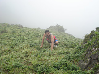

There are about 100 steps to be climbed at the peak. It was full of mist when we were climbing and we could not see the steep slope below (which, we were hoping to see as it was one of the views couldn't be missed). As we were climbing all of us' ears started paining because of chilling cool weather. Quite a bit crowd was already there by the time we reached.


Finally after an hour, we started back to resume our participation in the wedding! To end with, it was a Fantastic place, which, better be experienced than expressed in words.

Hassan Travel Loc 1 - Shravanabelagola
Hassan Travel Loc 2 - Manjarabad Fort

Tuesday, October 4, 2011

Hassan Travel 2 - Manjarabad Fort


Having finished lunch at Hassan, we didn't go to hotel that was booked for us. Instead we continued on NH48 towards Sakaleshpur for our next place - Manjarabad fort.


It is on a hillock beside NH48 at a distance of 7 km from Sakaleshpur towards Mangalore. There is a village by name Donigal where trucks stop for a cup of hot coffee. The path adjacent to these shops, rather canteens, leads to Manjarabad fort. The fort was constructed by Tippu Sultan, then king of Mysore. Started in 1785, it took 7 years to complete.


Primarily, the star-shaped fort was constructed as part of defense strategy to see British Army from Mangalore. Also, it was used to store ammonium, horses, and a secret tunnel to Srirangapatna, capital of Tippu Sultan. However the tunnel is closed now. There were lot of chambers and we were told they were used to house horses, used as kitchens, bathrooms apart from storing war weapons. In the middle of the fort, there is a well/pond with 'plus' shaped stairs leading to it, which was the source of water back then.


It was drizzling when we went and we drenched. However we didn't quite feel it since our minds were filled by the spectacular view of western ghats the fort was providing.


This is Manjarabad fort from Google Maps, satellite view


After about an hour, we got back to our car and returned to Hassan.

Hassan Trip Loc 1 - Shravanabelagola

Tuesday, September 27, 2011

Hassan Travel 1 - Shravanabelagola

One of my friends was getting married on August 15th (what a co-incidence!) at Hassan. We planned to go by car on 14th morning itself and visit some places near Hassan. Since all of us had been to Belur and Halebeedu, we finalized on 3 places to visit. Shravanabelagola, which is just a few km off Bangalore - Mangalore highway (NH48), was the first one.


Shravanabelagola town is situated between two hills Vindhyagiri and Chandragiri with a tank in between, namely, Belagola meaning Bili Kola or white pond. Shravana or Shramana means Jain ascetic, meaning, lifestyle practiced to pursue religious and spiritual goals avoiding worldly pleasures. The town is named after this Jain ascetic and pond. The place is a Jain pilgrimage center as there is 57 feet monolithic statue of Gomateshwara on southern hill, Vindhyagiri facing North.


The statue, center of attraction, is the tallest monolithic statue in the world. The statue is carved beautifully as if anthills surround it and creepers encircle up to thighs. According to the information available, it was installed by Ganga King Rachamalla Sathyavaka's minister Chavundaraya in 988 AD. Gomateshwara or Bahubali was a son of first Jain Thirthankara, Purudeva. He was transformed after he won the fight for kingdom fought against his brother Bharatha.


When we left Bangalore it was 9 am and we stopped for breakfast at Hotel Mayura, Ballur cross. It was very expensive and the service was slow. From NH48, we turned left to Shravanabelagola at Hirisave, roughly 125 km from Bangalore. From there, it is 18km.


We trekked amid hot Sun and visited Basadis on top of the hill and tried our luck to encircle Thyagada Kamba, a pillar and if one encircles by his hands it is believed to be a lucky symbol. On our way up, we saw a lot of people climb up 2-3 times to offer some religious vows, many a times, holding children. After circling round the statue, seeing all 24 Thirthankaras and overwhelmed by the Majestic statue, we took some snaps of the inscriptions and started back.


We climbed down, had tender coconut water and started towards Channarayapatna, at a distance of 11km, (different road than the one towards Hirisave) and from there to Hassan.

Sunday, September 18, 2011

Flopped Antharagange Trip

"We must go somewhere outside Bangalore", my friend called me. It was already 10 am and we had just finished breakfast. I quickly considered quite a few options and decided on Anthargange. Following a blog by someone I don't know, I thought it would be a nice trek with caves on top of the hill. But little did I know my plan would be ruined that day.


By the time we got ready and leave the Bangalore, it was nearing 1 pm. We didn't stop till a Shanti Sagar on the outskirts of Kolar. We had lunch there. It was good until my wife got a cockroach free with the lunch!
We almost finished our lunch, so we started towards Anthargange querying the route. I do not write the route here since we took too many alternate routes as many roads were dug up in Kolar. Finally we got a tarmac road to Anthargange, but by then, it was cloudy and very dark. Time was around 3 pm.


We reached Anthargange and parked our car. There is a police substation and a constable at the base from which there are steps to temple at a distance of approximately 300mts. He noted down everybody's name and sought address in detail. When I inquired about caves, he said there were no caves. We should not go beyond temple. There was a hillock range but it was the place of leopards There would be illegal activities going on and family people should not go. etc., To add to our dismay, drizzling started. Bottom line is our plan to trek and see the caves was shattered.


Anyway, being come so far, we thought of visiting temple atleast and return. There are too many monkeys in Anthargange. They literally attack each and everybody for the reason they only know. One monkey came and it almost attacked my wife and she, in order to escape, gave her bag to it. Monkey was confused on getting the bag without much effort, so it sat upfront scratching head. By then my wife realized her mistake and told our home key, wallet, everything was in the bag.

Now, it was our turn to attack the monkey and get the bag back. It was groaning but still sitting in front of us. When I tried to snatch the bag it tried to hit me and I took back my hand quickly. My friend was holding a stick with a lot of leaves so I told him to shove towards it. When money turned towards it in defense, I snatched the bag, this time very quickly. After that, we climbed up hurling sticks at monkeys.


We had not even reached the temple when heavy rain started pouring. We stood there for sometime watching rainfall. It was 4 30 pm when we got back to car and drove towards Bangalore.


I plan to visit again with proper route map to trek and reach the top and caves.

Saturday, July 9, 2011

Yana and Betthageri Beach

During Ugadi festival time, we had been to native and decided to go for a day's trip. My brother wanted to go to a beach. Only me and my wife had seen Yana and no one else had. So we planned to visit Yana and go to Kumta for lunch and then head to Betthageri beach for sunset and return home.

It was a Sunday, 3rd April, and we were on our way to Yana. Yana is a village in Uttara Kannada district amid Sahyadri hills (Western Ghats) range with presence of huge unusual rocks. These rocks are formed of crystalline limestone. There is a popular saying in Kannada "Sokkidre Yana Rokkidre Gokarna", meaning, one needs quite a bit stamina to trek to Yana and needs quite a bit money to reach Gokarna, since, for outsiders, Gokarna would be expensive enough. But today, this saying is not applicable for both of the places! After Kannada movie "Nammoora Mandara Hoove" (1997), Yana became more famous and now there is a tar road, going very near to Yana and the trekking distance is reduced to only half a km.


We reached Yana via Sirsi, and taking Kumta road, soon followed by taking a deviation to the right. The distance from Sirsi is around 40km. We first visited the temple, a Shiva temple. For "Pradakshine", one needs to go inside the gigantic rock. The path inside resembles cave and there are a couple of small rocks hanging in the narrow space in between the rock. We had tender coconut, banana before resuming journey to next destination.


There are two roads from Yana to Kumta, our destination. One route is via Mabage village and waterfall, called Vibhooti falls. I had been to there and have had a blog posted about it. Click here to read. The other route is taking the route towards Sirsi and take a deviation to Manjuguni after about 20km, which would join to Sirsi-Kumta road. We took the former route as it was nearer, 48 km. One can find many pages in internet about the distance from Yana to Kumta mentioned as approximately 25 km. But this is wrong and via the shortest route, Kumta is at a distance of 48 km from Yana. However, from Yana till Mabage the road is very bad with jelly (crusher stones) and to travel 7 km on empty road, we took more than half an hour! We had some food, packed from home, and went to Kumta. After a pit stop for coffee/snacks, we head towards Honnavar and took a right for Betthageri beach, roughly 10 km from Kumta on NH17.

Betthageri beach is very clean, as it is still remote. When we went there, there was nobody else, though some people came after us from neighboring villages after sometime. We played for an hour in the beach and just when the Sun started to set, it became cloudy and though we got nice views, we didn't get nice sunset!


We returned to home from there via Honnavar and Gerusoppa. It was a wonderful trip with full family after a long time.

Saturday, June 13, 2009

Shivagange - A Holy Rocky Hillock

"Lets go to Nandi Hills", I said, "But we have to be there by 6 am!".

We were planning for the next day, i.e., 15th Aug (2008). But in the evening, it rained so heavily that made us to drop the idea of being there on the summit by 6 am. Not just that, we even dropped Nandi Hills picnic, which never came true till today!We inquired some friends and decided on Shivagange, a rocky hillock and a fantastic trekking place with temples at the summit. The place is around 60 km from Bangalore towards Tumkur. A deviation has to be taken from NH 4 at Dabas pet and travel for 8 km to reach at the base, though the hillock is visible from Highway.


Me, Jagga and Acharya started by 9 am and picking up Manu, Prasanna and Deva on the way, all wearing jackets to protect from rain, set towards it and reached by around 11. Thanks to Varuna, the rain God. Nevertheless the weather was so nice and with clouds covering entire sky, Sun was not visible, A happy sign for trekkers.


We started climbing the hillock and we struggled a lot to keep the biscuits and chips with ourselves when our so called ancestors were trying desperately to drag them away. I am talking about monkeys, which would be there in large number at Shivagange. At once it jumped at me and even opened the zip of my bag to peek inside! So daring. Its a challenge how much you can keep before reaching the summit.


Half way, there is a place called "Olakallu Teertha", where, inside a cave, a small well with a diameter of 3/4th a foot is there. There is water in it but one has to shove his hand till the shoulder to reach the water. If he touches it, it is believed he has good luck, otherwise considered bad luck.


We took around 2 and half hours to reach the summit, eating cucumber, watermelon and drinking buttermilk on the way, including testing our luck by reaching water inside the well. The scenery is so fantastic and fabulous that I can never forget, at least in the near future. There is a suicide point also and a kannada novel refers it to as "Shantala's suicide point". I am not sure but I guess a character named Shantala committed suicide by jumping down in the novel at that place.


After photo sessions, we climbed down, which took an hour and a half approximately. But Varuna thought he should not keep quiet and heavy rain started pouring when we just started our ride and not even reached Dabas Pet. Finally, when it sl0wed down we resumed towards Bangalore and reached not before having snacks at Kamat hotel, Dabas Pet.

For more photos please follow this link http://picasaweb.google.com/gowthuhk/ShivagangeTrip#